Upon your arrival in Kathmandu, Nepal, a friendly representative from Manaslu Trek will greet you at the airport and escort you to your hotel. This marks the beginning of your Manaslu Circuit Trek adventure, offering a smooth and comfortable start to your journey in the Himalayan region.
In the evening, we host a special welcome dinner featuring authentic Nepalese cuisine, accompanied by a refreshing reception drink. This welcome evening also provides an opportunity to meet your fellow trekkers, discuss the Tsum Valley Trek itinerary, and receive essential tips for trekking in the Himalayas, including acclimatization, packing, and safety advice. Starting your journey in Kathmandu allows you to ease into the adventure while enjoying the city’s vibrant culture and setting the stage for your unforgettable Himalayan trekking experience.
Transfer: 30-45 min |
Accommodation: Hotel |
Meal: Welcome Dinner
Today, explore the rich culture, history, and heritage of Kathmandu Valley on this full-day city tour before your Tsum Valley Trek and Manaslu Circuit Trek. The tour takes you to some of Kathmandu's most famous UNESCO World Heritage Sites, offering a perfect introduction to Nepalese art, architecture, and traditions with our professional English-speaking City Tour Guide:
- SWOYAMBHUNATH , also known as the Monkey Temple, is one of Kathmandu Valley’s most iconic Buddhist stupas. Perched on a hilltop, it offers panoramic views of Kathmandu city and features ancient shrines, prayer wheels, and intricate carvings. The site is a spiritual and cultural landmark, attracting both pilgrims and tourists.
- KATHMANDU DURBAR SQUARE is a UNESCO World Heritage Site and the historic heart of Kathmandu City. Known for its ancient palaces, temples, courtyards, and intricate wood carvings, it reflects Nepalese art, culture, and architecture. A visit to this iconic square offers a glimpse into the royal history of Nepal.
- BOUDHANATH STUPA is one of the largest and most important Buddhist stupas in Nepal and a UNESCO World Heritage Site. Known for its massive white dome, colorful prayer flags, and iconic Buddha eyes, it serves as a major center for Tibetan Buddhism. Visiting Boudhanath provides an immersive cultural and spiritual experience.
- PASHUPATINATH is one of Nepal’s most sacred Hindu temples, dedicated to Lord Shiva and located on the banks of the Bagmati River in Kathmandu. Famous for its intricate pagoda-style architecture, cremation ghats, and spiritual rituals, it offers visitors a deep cultural and religious experience.
Our knowledgeable guide will tell you interesting things about the religious, historical, and architectural importance of each landmark. Kathmandu is a unique city with a rich culture and a spiritual atmosphere that will make your city tour an interesting and memorable way to learn about Nepalese heritage.
Sightseeing: 7-8 Hours |
Accommodation: Hotel |
Meal: Breakfast
After breakfast in Kathmandu, take a scenic drive of about 144 km to Gorkha Bazaar, which usually takes 5 to 7 hours by private vehicle, depending on traffic. The journey follows the Prithvi Highway, passing towns like Naubise, Malekhu, and Mugling, and running along the sparkling Trishuli River. At Malekhu, stop for a fresh cup of tea, coffee, and light food and watch whitewater rafters on the riverbanks—a classic roadside experience. From Abu Khaireni, leave the main highway toward Pokhara and climb the last 24 km uphill through terraced farmland, forests, and traditional Newari and Magar villages, gradually entering the cooler mountain region. Upon arrival in Gorkha Bazaar, check in at your hotel and enjoy a refreshing cup of tea or coffee to recharge before the afternoon climb.
In the late afternoon, hike up to Gorkha Durbar, the ancestral palace of the Shah dynasty and birthplace of King Prithvi Narayan Shah. The climb involves approximately 1,500 stone steps, shaded by ancient trees and lined with small shrines. The Durbar is a beautiful example of Newari architecture, with intricate wood carvings, red-brick walls, and a mix of fort, palace, and temple. Visit the sacred Kalika Temple and Gorakhnath Cave, where the sage once guided the young king. As the sun sets, enjoy panoramic views of Boudha Himal, Himalchuli, Langtang, and the Annapurna range, with the Daraundi River winding below and the bazaar lights sparkling.
Transfer: 140km, 5-6 Hours |
Accommodation: Hotel l
Meal: Breakfast, Lunch, Dinner
After breakfast in Gorkha, the drive starts by going down from the historic Gorkha ridge toward the lower parts of the district. Along the way, we pass local spots like 13 Kilo and 12 Kilo, where the city influence fades, the air gets warmer, and the plants become more tropical. At Chepetar, the land flattens into wide, green plains with paddy fields and traditional thatched houses, while the turquoise Daraudi Khola flows beside the road. Baluwa is an important stop and often the last place to find a tea shop before the road climbs steeply. After crossing the river near Baluwa, the road winds upward into the hills with sharp turns and cliffs, reaching Rangrung, where the air is cooler, the pine scent fills the air, and the Daraudi River winds below. Passing Mandre, the local communities change from Brahmin and Chhetri settlements to the stone-and-wood houses of Gurung people, with small terrace farms on the mountainsides. Finally, rounding the last bend, Barpak (1,950 m) comes into view, a large village with hundreds of houses clinging to the slope like a fortress. It is known as the home of the Ghale Kings and a recruiting place for Gurkha soldiers, and it was also the epicenter of the 2015 earthquake.
After a hearty lunch in the stone-paved alleys of Barpak, the trek to Laprak begins, taking roughly 4–6 hours and weaving together ancient Gurung traditions with modern resilience. The trail climbs steeply, offering sweeping views of mountains, scattered villages, and the Daraundi Valley. About three hours in, you reach Momche Danda (2,950 m/9,678 ft), a high ridge dotted with rolling pastures and grazing sheep, providing breathtaking panoramas of the Himalayas. From Momche Danda, the trail continues through lush rhododendron forests, which burst into vivid reds, pinks, and whites in spring, framing stunning vistas of the Manaslu Massif, Buddha Himal, and Shringi Himal. The descent leads first to New Laprak (Gupsi Pakha), a modern, earthquake-resistant settlement, before reaching Old Laprak Village. Here, traditional timber-framed houses, narrow alleys, and mud-brick murals preserve the Gurung heritage.
Transfer: 70km, 3-4 Hours |
Trekking: 5-6 Hours |
Distance: 9 km |
Altitude Gain: 930 m |
Altitude Loss: 770 m |
Accommodation: Lodge l
Meal: Breakfast, Lunch, Dinner
After breakfast in Laprak, the trek begins in the crisp morning air, leaving the village as the sun lights up the slate roofs and smoke rises from Chulo stoves. The trail first drops sharply through fertile terraces of barley and buckwheat, showing the “vertical lifestyle” of locals carrying heavy loads up the slopes. At the base of the valley, we cross the Jyabru Khola on a traditional suspension bridge, where the air is more humid and the forest changes from pines to ferns and broadleaf trees. After the river, the trail climbs steeply, passing terraced fields of pink sorghum and winding along narrow paths that lead to a small chorten below Singla, a quiet mid-hill village with houses decorated with drying corn husks and marigolds, perfect for a mid-morning break with fresh buffalo milk tea. From the ridges near Singla, we enjoy views of Ganesh Himal to the east, the Gupsi Danda ridge behind us, and further north, the Kutang Himal and Sringi Himal, standing on the divide between the Daraudi and Budi Gandaki watersheds. The path then continues through more terraced fields, papaya trees, and the Gurung village of Khorla, passing bamboo groves, wild herbs, and citrus orchards along narrow stone-lined paths, with local women weaving straw mats along the way. The day ends with a steep descent to Khorlabensi (970 m) on the Budi Gandaki River, where the roar of the river grows louder, the canyon walls are dramatic, and trekkers may cross a long suspension bridge. In the evening, the riverside village with narrow streets and cozy lodges often welcomes guests with cultural performances, offering a glimpse into local traditions after a long day of trekking.
Trekking: 7-8 Hours |
Distance: 14 km |
Altitude Gain: 580 m |
Altitude Loss: 1,740 m |
Accommodation: Lodge l
Meal: Breakfast, Lunch, Dinner
After breakfast in Khorlabeshi, the trek begins with a scenic walk along the Budhi Gandaki River, passing through lush greenery and small coffee plantations until you reach Tatopani, where natural hot springs offer a refreshing stop for trekkers. After leaving Tatopani, you cross a suspension bridge to the eastern side of the river, and the valley gradually becomes narrower with the sound of rushing water growing stronger. Continuing, you arrive at Doban, a popular lunch spot at the meeting point of two rivers, where the trail becomes more rugged with landslide-prone sections, so it’s important to stay alert and always stand on the mountainside when mule trains pass. As you move toward Yaruphat, the landscape becomes more dramatic, featuring a long metal cantilever bridge fixed to a cliff that helps you safely cross a once-dangerous section, along with a stunning waterfall nearby. The day ends with a steady climb up stone steps to Jagat, a tidy village with paved paths that serves as an official checkpoint for the Manaslu region, where you’ll also notice stronger stone-built houses designed for the cooler mountain environment.
Trekking: 7-8 Hours |
Distance: 14 km |
Altitude Gain: 620 m |
Altitude Loss: 170 m |
Accommodation: Lodge l
Meals: Breakfast, Lunch, Dinner
After breakfast and permit verification, the trek begins from Jagat with a gentle climb on a stone-paved trail, descending to the riverbank and passing Salleri, where you enjoy the first clear views of Sringi Himal and nearby waterfalls. The route continues along the Budhi Gandaki River to Sirdibas, a traditional Gurung village known for its stone mani walls and small gompas, before dropping to cross a suspension bridge at Ghatte Khola. From there, the trail climbs steadily through terraced hills to Philim, a large village surrounded by corn, millet, and potato fields, often used as a lunch stop with wide valley views. After Philim, the path heads north through forested terrain and waterfalls, passing Ekle Bhatti and reaching a key junction where the trail splits between the Manaslu Circuit and Tsum Valley; taking the right turn, you cross a high suspension bridge and enter a remote wilderness of pine and rhododendron forests. The trail then continues through the narrowing gorge of Thangurmu, where cliffs rise sharply and the river roars far below, before a final steep and switchback ascent leads to Lokpa at 2,240 meters. Lokpa, the quiet gateway of the Tsum Valley, offers a strong sense of isolation and marks the beginning of the sacred high Himalayan sanctuary beneath the Ganesh Himal range.
Trekking: 6-7 Hours |
Distance: 14 km |
Altitude Gain: 810 m |
Altitude Loss: 230 m |
Accommodation: Lodge l
Meals: Breakfast, Lunch, Dinner
After breakfast, the trek from Lokpa begins with a steep descent through a wild forest of pine and rhododendron toward the roaring Siyar Khola, where you cross a suspension bridge that marks the official entry into the inner Tsum Valley. From here, the trail becomes a steep and tiring uphill climb with narrow cliffside paths and stone switchbacks, offering stunning views of Ganesh Himal and Baudha Himal along the way. As you gain height, the forest slowly changes from dense woodland to more open alpine scenery with streams and waterfalls flowing down the rocks. After a steady climb, the trail finally levels out as you reach Chumling (2,385 m), a peaceful hillside village divided into Upper and Lower sections. Here, the landscape opens into terraced fields and a strong cultural setting with ancient Mani walls, sacred Chortens, and traditional stone houses with wooden roofs, showing the spiritual heart of Lower Tsum. The turquoise Siyar Khola continues below, fed by glaciers from the inner valley, while the Ganesh Himal range dominates the skyline on clear days. This 4–5 hour trek is a great introduction to Tsumba culture, and it is important to walk clockwise around religious monuments and carry enough water and snacks, as there are few stopping places along the route.
Trekking: 4-5 Hours |
Distance: 8 km |
Altitude Gain: 710 m |
Altitude Loss: 310 m |
Accommodation: Lodge l
Meals: Breakfast, Lunch, Dinner
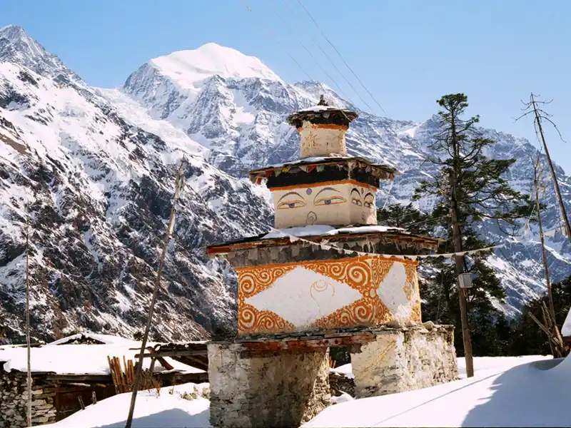
After breakfast in the Chumling, the trail goes over a suspension bridge and through the lush greenery of Rainjam. As you leave the humid river zone, the air gets thinner, and the weather gets drier. As the journey continues, there is a steady, steep climb up stone switchbacks. The climbers are rewarded with stunning views of the Ganesh Himal as they leave the dense rhododendron forests behind. Once you get to the high ridge, the land flattens out into a wide, sunny valley floor at Chhokangparo, which is the official entrance to Upper Tsum and is known for its traditional stone homes with flat roofs and huge, holy Mani walls. This day hike will be your first night above 3,000 meters. Stay hydrated and take it easy while you enjoy the "Sacred Valley of Non-violence" and maybe even a cup of traditional Tibetan butter tea with the friendly locals.
Trekking: 6-7 Hours |
Distance: 11 km |
Altitude Gain: 910 m |
Altitude Loss: 180 m |
Accommodation: Lodge I
Meals: Breakfast, Lunch, Dinner
From the twin villages of Chhokangparo, the trail leads through fields of buckwheat and barley to the traditional settlement of Lamabagar, surrounded by the majestic Himalchuli and Ganesh Himal ranges. A spiritual highlight comes near Burji, where a short detour leads to the sacred Milarepa Piren Phu Cave, a cliffside sanctuary where the legendary Tibetan saint meditated that now houses ancient murals and a revered rock footprint. After taking in the peaceful surroundings, you will walk through the historic village of Chule (3,347 m), which is famous for its impressive Mani walls and large school. Then, you cross a sturdy bridge over the Shiar Khola. The 5-6 hour journey ends with a gentle climb to the Nile (3,361 m), a charming high-altitude village with stone-walled houses that serves as your final base before ascending to Mu Gompa. To ensure a smooth experience, remember to follow cave etiquette by removing your shoes, applying high-SPF sunscreen against the intense high-altitude sun, and staying hydrated as you settle in for the night at over 3,300 meters.
Trekking: 6-7 Hours |
Distance: 10 km |
Altitude Gain: 320 m |
Altitude Loss: 40 m |
Accommodation: Lodge I
Meals: Breakfast, Lunch, Dinner
After breakfast in Nile, the day hike begins with a steady morning ascent along the Shiar Khola's western bank through a stark, alpine landscape of seasonal yak pastures. The trail gradually ascends to Mu Gompa (3,700 m), the largest and highest monastery in the Tsum Valley. Established in 1895, this sacred site houses invaluable religious texts such as the Kangyur, a life-sized statue of Avalokiteshwara, and revered images of Guru Padmasambhava and Tara. For those seeking a "top of the world" experience, an optional trek leads further to the historic Dephyudonma Gompa (4,060 m), one of the valley's oldest nunneries, founded by Lama Serap of Nile Ladrang, with unparalleled views of glaciers and the Tibetan border. This 4-6 hour round trip should begin by 7:00 a.m. to avoid the midday clouds and capture the best photography light before a quick, scenic descent back to Nile for the evening. Hikers should carry a light pack with a down jacket and high-energy snacks, take advantage of the available drinking water sources, and follow traditional etiquette by dressing modestly and removing headwear when entering these ancient prayer halls.
Hiking: 5-7 Hours |
Distance: 10 km |
Altitude Gain: 320 m |
Altitude Loss: 320 m |
Accommodation: Lodge I
Meals: Breakfast, Lunch, Dinner
After breakfast in Nile, the trail follows the Shiar Khola downstream on a wide, mostly flat path through the fertile valley. There are stunning views of the Pika Glacier and the Ganesh Himal range's tall peaks. You get to Rachen Gompa, an important nunnery built by the Ngak-pa sect in 1905 that is known for its beautiful Buddhist murals and large collection of statues. From Rachen Gompa, the road goes south through the twin villages of Lar and Phurbe to Chhekampar, which is the largest settlement in Upper Tsum and is made up of the villages of Chheko and Par joined together. It has traditional Tibetan-style stone houses with stacks of firewood on top, and there are several teahouses that make it a great place to stop for lunch. The trail goes down steeper for 2.5–3 hours after Chhekampar. It goes from a dry alpine landscape to a forest of blue pine and rhododendrons, crossing a few suspension bridges over the Shiar Khola on its way to Gho, a small, quiet village at a lower elevation where the air is noticeably warmer and more comfortable. Along the way, don't forget to look left at the mani walls and chortens, and ask permission before taking pictures inside Rachen Gompa. As you descend toward Gho, keep an eye out for yellow-flowering Himalayan gorse and the fresh scent of pine.
Trekking: 5-7 Hours |
Distance: 15 km |
Altitude Gain: 70 m |
Altitude Loss: 870 m |
Accommodation: Lodge I
Meals: Breakfast, Lunch, Dinner
From Gho, the trail gently descends through peaceful pine and rhododendron forests to the confluence of the Shiar Khola and Sarpu Khola, arriving at the small settlement of Dumje, the day's lowest point and a quiet junction where water bottles should be refilled before the exposed climb ahead. After crossing a suspension bridge over the Sarpu Khola, the route sharply ascends and begins a demanding climb to Gumba Lungdang, zigzagging through dense, moss-covered forest and, in spring, brilliant rhododendrons, with a few "false peaks" along the way that test patience and pacing. As you finally reach the ridge, the nunnery appears as an eagle's nest against the massive backdrop of Ganesh Himal (Yangra), one of the region's oldest and most significant nunneries, with arguably the best view of Ganesh Himal I (7,422 m) in the entire Tsum Valley. Accommodation in the nunnery's guest rooms is simple, with basic meals prepared by the nuns, and if you arrive before sunset, you may have the rare opportunity to witness the evening puja, when the deep sounds of horns and drums echo hauntingly across the surrounding mountain walls.
Trekking: 5-6 Hours |
Distance: 7 km |
Altitude Gain: 1,010 m |
Altitude Loss: 200 m |
Accommodation: Lodge I
Meals: Breakfast, Lunch, Dinner
After breakfast, the route begins directly behind the nunnery with a steep climb through dense rhododendron and pine forest, where the narrow trail can be slippery in morning dew or after rain. The scenery drastically shifts as you rise above the tree line onto the Toro Gompa Glacier's lateral moraine. Here, the path becomes faint, and you must carefully scramble over large, unstable boulders and loose scree to find your way. Previous hikers have left small stone cairns. Reaching Ganesh Himal Base Camp—more a broad, rocky expanse than a defined campsite—you find yourself standing directly beneath Ganesh Himal I (7,422 m), with sweeping views of Ganesh II and IV and the massive glacier icefall, at an altitude of roughly 4,200 m, where it’s important to be alert to any signs of altitude discomfort and descend promptly if symptoms arise. The return journey is demanding, with knee-testing descents over loose moraine and a steep, jarring drop back through the forest, so plan to be back at the Gumba by mid-afternoon before temperatures fall and clouds build.
Hiking: 8-10 Hours |
Distance: 22 km |
Altitude Gain: 1,280 m |
Altitude Loss: 1,280 m |
Accommodation: Lodge I
Meals: Breakfast, Lunch, Dinner
After breakfast in Gumba Lungdang, you begin a steep descent by retracing the ridge down through rhododendron and pine forest, where the sharply dropping, sometimes slippery trail makes trekking poles especially helpful, eventually reaching the small settlement of Dumje, a convenient spot for a short rest or snack before continuing. From Dumje, instead of crossing back toward Gho, the route follows the southern bank of the Shiar Khola westward on a relatively gentle, undulating path through deep, ancient forest to Ripchet, one of the most traditional villages in the valley, distinguished by dry-stone houses with wooden roofs and a quieter, more shaded atmosphere that makes it an excellent place for lunch and observing local agricultural life. The final stage leaves the open Tsum Valley plateau and descends steeply from the Ripchet fields into a narrow gorge, crossing a long suspension bridge over the Shiar Khola to rejoin the main trail, followed by a short uphill climb and some narrow cliff-side sections before reaching Lokpa. Lokpa, the entrance to the Tsum Valley, is situated high above the thunderous meeting point of the Shiar Khola and Budhi Gandaki.
Trekking: 7-8 Hours |
Distance: 18 km |
Altitude Gain: 550 m |
Altitude Loss: 1,970 m |
Accommodation: Lodge I
Meals: Breakfast, Lunch, Dinner
After breakfast in Lokpa, the trek starts with a steep descent to the confluence of the Syar Khola and Budhi Gandaki River, followed by a suspension bridge crossing and a tough climb up to the traditional village of Nyak, which offers beautiful views of deep gorges. From Nyak, the trail goes back down to the river and continues along narrow paths carved into cliffs, with many ups and downs and several suspension bridge crossings until reaching Pewa, a quiet riverside place ideal for lunch. The route then gradually continues to Deng (1,860m), an important gateway into the Kutang region where Tibetan Buddhist culture becomes more visible in the form of prayer flags, mani walls, and local traditions. After leaving Deng, the trail continues through forests and rugged terrain as we follow the Budhi Gandaki Valley, passing small villages, wooden bridges, and mule caravans along the way. The landscape keeps changing, with dense forests opening to views of tall Himalayan peaks like Lapuchang and Chhachung near the Tibetan border. Finally, the trail climbs steadily to reach the peaceful village of Bihi (2,130m), a quiet settlement with stone houses and terraced fields, offering a more authentic and calm overnight stop compared to busier villages on the route.
Trekking: 7-9 Hours |
Distance: 15 km |
Altitude Gain: 1,190 m |
Altitude Loss: 950 m |
Accommodation: Lodge I
Meals: Breakfast, Lunch, Dinner
After breakfast in Bihi, the trail crosses the Budhi Gandaki River and climbs steeply through forests of pine and rhododendron toward the plateau village of Prok, where you will see terraced fields, a small monastery, and wide views of the surrounding hills. From Prok, the trail descends through forest paths to Ghap, a small village known for its detailed mani walls and a popular lunch stop where trekkers rest and eat. After lunch, the route continues along the Budhi Gandaki Gorge, crossing suspension bridges and walking through dense forests where you may spot wildlife like langur monkeys before making a steady climb away from the river toward Namrung (2,660 m). As you reach Namrung, the landscape and culture change noticeably into the Upper Manaslu region, with more Tibetan-style villages, traditional stone houses, and the first clear views of peaks like Siringi Himal and Ganesh Himal, making this a very scenic and culturally rich day on the Manaslu Circuit.
Trekking: 5-7 Hours |
Distance: 13 km |
Altitude Gain: 990 m |
Altitude Loss: 420 m |
Accommodation: Lodge I
Meals: Breakfast, Lunch, Dinner
After breakfast in Namrung, the trek starts with a gentle climb to Lhi (2,900m), where you will see a clear change in village style, with traditional stone houses, terraced fields, and views of Himal Chuli (7,893m) in the distance. From Lhi, the trail continues to Sho (3,000m), crossing a deep ravine and passing through the Hinang valley, where you can also make a short side trip to Hinang Gompa to see the glacier and icefall. After a short rest in Sho, the trail climbs steadily to Lho (3,180m), an important village known for Ribung Gompa and its amazing view of Mount Manaslu rising above the valley. Lho is also a good place for lunch, with several lodges and a lively monastery atmosphere. In the afternoon, the trail goes through a forest of birch, fir, and rhododendron, then makes a final climb to Shyala, a wide-open plateau village known for its 360-degree mountain views. From Shyala, you can see major peaks like Manaslu, Manaslu North, Himal Chuli, Ngadi Chuli, and even distant Ganesh Himal, making this one of the most beautiful days of the Manaslu Circuit.
Trekking: 6-8 Hours |
Trekking: 13 km |
Altitude Gain: 1,130 m |
Altitude Loss: 300 m |
Accommodation: Lodge I
Meals: Breakfast, Lunch, Dinner
After breakfast in Shyala, we start early to enjoy clear views of Mount Manaslu, Himal Chuli, and Ngadi Chuli before the clouds arrive. The trail first goes slightly downhill and then turns off the main route toward Pung Gyen Gompa, where the climb begins. The path becomes steep as we leave the forest and walk on rocky moraine, gaining elevation and feeling the air getting thinner. Gradually, the landscape opens into a wide alpine plateau with golden grass and grazing yaks, and sometimes you may see Himalayan blue sheep. At the end of the plateau, we reach Pung Gyen Monastery, a small rebuilt monastery set in a quiet, open area at the base of the huge east face of Mount Manaslu, where glaciers, ice, and distant avalanches can be seen and heard. We enjoy lunch here while taking in the amazing views that stay in memory for a long time. After spending time at the monastery, we descend back the same way and take the lower trail toward Samagaun, passing stone fields, mani walls, and mule caravans. Finally, we reach Samagaun (3,530m), a large traditional Tibetan-style village where we can rest in a teahouse and, if time allows, visit nearby monasteries like Kargyu Chöling.
Trekking: 6-8 Hours |
Distance: 13 km |
Altitude Gain: 570 m |
Altitude Loss: 560 m |
Accommodation: Lodge I
Meals: Breakfast, Lunch, Dinner
Today is an acclimatization day in Samagaon, giving us time to rest, adjust to the altitude, and prepare for the days ahead. We have two great options: a short and easy hike to Birendra Tal (3,691 m) or a more challenging trek to Manaslu Base Camp (4,800 m). The walk to Birendra Tal takes about 45 minutes to an hour on a mostly flat trail, passing mani walls and chortens along the Manaslu Glacier, leading to a peaceful, emerald-colored lake surrounded by ice cliffs, where you may hear distant avalanches. Many people return from here, but if we continue to Base Camp, the trail becomes steep and demanding, climbing over 1,200 meters in 4–5 hours. The path goes through rocky terrain with less vegetation and thinner air, making the walk slower and more tiring. However, the reward is incredible, with close views of Mt. Manaslu and nearby peaks like Himalchuli and Ngadi Chuli, along with the large Manaslu Glacier below—making it a truly unforgettable experience.
Hiking: 7-8 Hours |
Distance: 15 km |
Altitude Gain: 1,320 m |
Altitude Loss: 1,320 m |
Accommodation: Lodge l
Meals: Breakfast, Lunch, Dinner
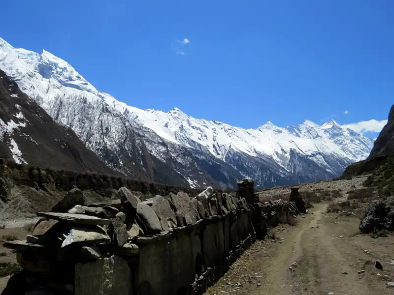
After breakfast in Samagaon, the trek follows the upper Budi Gandaki River as the green landscape slowly changes into dry alpine terrain, passing through birch and juniper trees before opening into rocky ground with small bushes. As the valley widens, you can enjoy wide views of Mount Manaslu (8,163 m) on the left and the rugged mountains near the Tibetan border on the right, while walking past mani walls and chortens, always keeping them on your left. Along the way, you pass the long mani walls at Kermo Kharka, then cross a small wooden bridge and climb gently to reach Samdo in about 3–4 hours, usually in time for lunch. The village appears as a group of stone houses under a rocky hill, marked by an entrance chorten and a “kane” gateway. After arrival, you can visit a small home gompa where local lamas perform prayers. In the afternoon, you can take an acclimatization hike above the village toward Samdo Peak, walking slowly on a steep and rocky trail in thin air, reaching viewpoints up to around 5,177 m. From there, you can see amazing views of Manaslu’s glaciers, Rani Peak, the route toward Rui La (4,998 m) and even the distant Tibetan plateau, along with glacial valleys and frozen lakes below.
Trekking: 6-8 Hours |
Distance: 13 km |
Altitude Gain: 1,610 m |
Altitude Loss: 1,250 m |
Accommodation: Lodge l
Meals: Breakfast, Lunch, Dinner
Leaving Samdo in the morning feels like leaving the last village behind, as you walk past stone houses and yak grazing fields. Near the edge of the village, you pass the old Larke Bazaar, which was once a busy trade point between Tibet and the lower regions, but now only ruins remain. The trail then goes down to cross a wooden bridge over the upper Budi Gandaki River, which has become a small, fast glacier stream, and then slowly climbs along the side of the Larke Glacier. As you go higher, the valley behind toward Lajyung La disappears, and the landscape becomes more rocky, empty, and cold. You may see blue sheep on the cliffs and pass mani walls with prayer flags, which are the last spiritual markers before the pass. After a few hours of steady walking, you reach Dharamsala (Larke Phedi) at 4,460 m, a simple seasonal stop with basic lodges and tents for trekkers and porters. The place is quiet, and everyone is preparing for the next day’s crossing of Larke Pass. After lunch, it is good to take a short walk uphill nearby to help your body adjust to the altitude, with great views of Larke Peak and the glacier below, making it an important rest and preparation day.
Trekking: 4-5 Hours |
Distance: 6 km |
Altitude Gain: 590 m |
Altitude Loss: 10 m |
Accommodation: Lodge l
Meals: Breakfast, Lunch, Dinner
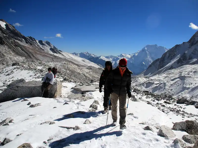
The day starts very early around 3:00 AM in the cold darkness of Dharamsala (Larke Phedi), where trekkers wake up in freezing temperatures of around -10°C to -15°C to cross Larke Pass before strong afternoon winds begin. The first part of the trek is a slow and steady climb over frozen scree and icy paths along the Larke Glacier moraine, moving at a careful, rhythmic pace in the dark with headlamps, passing small prayer flags and frozen lakes along the way. As the sun slowly rises over the surrounding Himalayan peaks, the final ascent becomes more visible, with thin air making every step harder and more deliberate. After hours of climbing, you reach Larkya La Pass at 5,106 m, marked by colorful prayer flags and surrounded by breathtaking views of peaks like Himlung Himal, Cheo Himal, Kang Guru, Gyaji Kung, and even distant Annapurna II, making it a truly rewarding moment.
From the pass, a very steep and long descent begins, which is physically tough on the knees as you walk down loose scree and sometimes snowy paths toward the valley below. The trail then follows the edge of the glacier moraine before gradually entering greener landscapes, where rocky ground turns into grass, shrubs, and finally beautiful alpine forests. After hours of downhill trekking, you arrive at Bhimtang at 3,720 m, a wide and peaceful valley surrounded by glaciers and mountains. Here, the tea houses feel warm and welcoming after a long day, and the incredible views of the Manaslu West Face and surrounding peaks make the effort of crossing the pass completely unforgettable.
Trekking: 7-9 Hours |
Distance: 16 km |
Altitude Gain: 680 m |
Altitude Loss: 1,450 m |
Accommodation: Lodge I
Meals: Breakfast, Lunch, Dinner
After breakfast in Bhimtang, the day begins with stunning views of Manaslu’s West Face and nearby peaks before you leave the sandy glacial basin and cross the moraine of the Bhimtang Glacier. Soon, the trail enters beautiful forests of rhododendron, pine, birch, and moss-covered trees that feel magical, especially in spring when the ground is covered with red, pink, and white flowers. As you descend further along the Dudh Khola, the air becomes warmer and easier to breathe. The first stop is Chauli Kharka, a wide pasture where yaks graze and trekkers take a short break, followed by Surki Kharka, where the forest becomes thicker, greener, and full of bird sounds. The trail then continues down to Karche, a peaceful village on a river terrace where it is a good place for lunch with dramatic views of the gorge below. After a short climb over a ridge, the path gently descends through terraced fields and farming villages, where you can see local life more clearly. Finally, you reach Gowa, a quiet agricultural village surrounded by barley, wheat, and potato fields, where the air is warm and comfortable, and teahouses offer a relaxing end to the day with hot showers and a sense of achievement after the high mountains.
Trekking: 5-6 Hours |
Distance: 14 km |
Altitude Gain: 50 m |
Altitude Loss: 1,240 m |
Accommodation: Lodge l
Meals: Breakfast, Lunch, Dinner
After breakfast in Gowa, the trek begins with a gentle downhill walk through green, fertile farmland and villages, where the air feels rich in oxygen, and the smell of woodsmoke and fresh earth replaces the cold mountain air. After about 1.5–2 hours, you reach Tilche, a large and traditional Gurung village with stone houses, paved paths, and a more permanent settlement feel. Around Tilche, you can see apple orchards and may also pass a police checkpost where trekking permits are officially stamped for the last time. From here, the trail descends toward the river and crosses a long suspension bridge over the Dudh Khola before climbing up to Dharapani. At this important junction, the Manaslu Circuit meets the Annapurna Circuit. In Dharapani, the atmosphere becomes busier, with more trekkers, better facilities, and official permit checks for the Annapurna Conservation Area. After lunch, the trail continues along the Marsyangdi River through a deep gorge with cliffs and waterfalls, sometimes following the old walking trail to avoid the nearby road. Finally, the valley opens up as you arrive at Tal, a beautiful village on a flat sandy valley floor with a large waterfall nearby, marking a warm and scenic end to this trekking section.
Walk: 5-6 Hours |
Distance: 17 km |
Altitude Gain: 140 m |
Altitude Loss: 990 m |
Accommodation: Lodge l
Meals: Breakfast, Lunch, Dinner
After breakfast in Tal, the drive begins with an exciting off-road jeep ride down the Marsyangdi Valley, where the road is carved into cliffs, and the river flows far below. Along the way, you pass villages like Chamje and Jagat, with waterfalls often splashing onto the road, and make a dramatic descent near Syange, where the huge waterfall marks your final view of the high mountains. As you go lower toward Besisahar, the cold alpine air turns warm and humid, and pine forests slowly change into banana trees, bamboo, and green rice fields. Besisahar is a busy town and the main gateway of the region, where many trekkers change from jeep to car or bus and enjoy their first proper “city-style” meal after days in the mountains. From here, the drive continues along the Prithvi Highway through the wide Marsyangdi Valley, passing hydropower projects and eventually reaching Mugling, a busy road junction at the meeting point of the Marsyangdi and Trishuli rivers, known for its heavy traffic, roadside restaurants, and river fish. The final stretch follows the Trishuli River, where you may see white-water rafting and winding roads through green hills before climbing up through Naubise toward Thankot. Finally, you enter Kathmandu Valley, where the mountains fade behind you and the landscape opens into a wide valley filled with houses, temples, and the busy capital city, marking the end of your Himalayan journey.
Transfer: 215 km, 8-10 Hours |
Accommodation: Hotel l
Meal: Breakfast, Lunch
Today is a free day in Kathmandu for shopping and other activities. You can explore the lively streets and local markets and buy souvenirs such as handicrafts, prayer flags, and pashmina. You may also try local food or visit nearby cultural sites like Bhaktapur or Patan to see traditional temples, palaces, and local heritage. If you prefer, you can join optional activities such as short hikes, cycling, or adventure experiences around the valley. Or you can simply relax at a café, spa, or hotel and rest after your trek. It is a good opportunity to enjoy the culture, atmosphere, and energy of Kathmandu at your own pace.
Accommodation: Hotel l
Meal: Breakfast
Today, we will transfer to Kathmandu International Airport for our departure. After enjoying a hearty breakfast at the hotel, we will gather our belongings and go to the airport. We will ensure we reach the airport well in time to complete all the necessary formalities and board our flight. Before we bid farewell to this enchanting country, take one last look at the breathtaking views of the Himalayas and take a moment to appreciate the warm hospitality and kindness of the Nepalese people. This marks the end of our tour, and we hope you had a memorable and enjoyable time in Nepal.
Meal: Breakfast
The Tsum Valley and Manaslu Trek 2026 cost on the website applies to groups of 6–12 people. However, private trips for groups of two or more can be organized upon request. A group booking of 12 or more people can offer a maximum discount with one free trip. Clients' travel date preferences can be accommodated, but the trek cost depends on group size, duration, accommodation type, and additional activities or services.
- Group Size: The cost of the trip will depend on the size of the group.
- Hotel Accommodation Category and Client's Budget: The cost may also vary based on the accommodation category and budget preference of the client.
- Itinerary Modification: Our trekking itinerary can be modified according to your time and requirements, and the cost will be adjusted accordingly.
- Additional Services: If you require additional services, the cost will be adjusted accordingly based on mutual understanding.
- Trekking Staff: The cost is also affected by the number of Trekking Guides, Assistant Guides, and extra porters required for the trip.
| Trip Dates | Trip Cost | Status | Inquiry |
| USD USD 2,700.00 Per Person | Available | Inquiry |
Cost Includes:
- Airport pick-up and drop-off services in private transportation before and after the trek.
- Hotel Accommodation: 4 nights in Kathmandu at a twin sharing room on the BB plan.
- City Cultural Tour in Kathmandu with the City Tour Guide and all the entrance and monument fees.
- Transportation: Kathmandu—Laprak and Tal—Kathmandu with a Guide.
- Breakfast, Lunch, and Dinner during Tsum Valley and Manaslu Circuit Trek.
- Best available lodges and guesthouses at a twin-sharing room for accommodation during the trek.
- Trekking Staffs: Experienced English-speaking Trekking Guide, Assistant Guide for a group of over six people and porters (2:1), including their daily allowance, meal, and accommodation.
- Accidental and medical insurance for Nepalese team.
- Trekking Permit: Special permit for Tsum Valley and Manaslu, Manaslu Conservation Area Project (MCAP), and Annapurna Conservation Area Project (ACAP) Entry Permit Fee.
- All government-applicable taxes
- Travel agency service charge.
Cost Excludes:
- Lunch and dinner in Kathmandu before and after the Tsum Valley and Manaslu Trek.
- International air ticket.
- Beverage, hard drinks, and alcohol.
- Nepal entry visa fee and airport tax during the departure.
- Extra supporting staff, laundry, battery charge, and communication expenses.
- Personal expenses like tea, coffee, bar bill, drinking water, beverage, snacks, hot shower, etc.
- Travel and medical insurance, emergency evacuation/natural disaster, or personal reasons.
- In any case of natural calamities, mishaps, or anything beyond our control.
- Tips and gratitude for the members of the trekking or the tour.
Please feel free to ask any questions.
1. Why the Tsum Valley and Manaslu Trek?
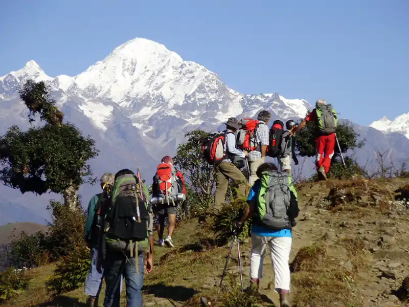
The Tsum Valley and Manaslu Trek is an exciting adventure in Nepal's remote Himalayas. It highlights the fascinating Tibetan Buddhist traditions as well as the mystical Tsum Valley location. Mount Manaslu, the eighth-highest peak in the world, serves as the focal point of the trek, which offers breathtaking views of snow-capped peaks and towering peaks. The best time to visit is in the spring (March to May) and autumn (September to November), when the skies are clear, the temperatures are pleasant, and the wildflowers are stunning. This trek offers a distinctive viewpoint of Nepal's remote Himalayas and provides an opportunity to explore historic monasteries and prayer wheels that reverberate mantras in the mountain breeze.
2. How difficult are the Tsum Valley and Manaslu treks?
The Tsum Valley and Manaslu Trek is a challenging yet rewarding journey through the Himalayas. To be successful, trekkers must be mentally and physically prepared for the challenges they will face. The trek includes steep ascents and descents, difficult terrain, and high altitudes. All trekkers are expected to be physically fit, with regular strength training and cardiovascular exercise, as well as prior experience trekking in high-altitude areas. Because of the significant elevation gain, altitude sickness is a risk, and adequate acclimatization is required before beginning the trek. This task includes gradual ascent, regular breaks, monitoring of body signals, and hydration. Despite the breathtaking Himalayan landscape and abundant cultural heritage, the Tsum Valley and Manaslu Trek offer an unforgettable experience; however, one must be physically and mentally prepared before embarking on this journey.
3. When is the best time to go on the Tsum Valley and Manaslu Trek?
The best time to go on the Tsum Valley and Manaslu Trek is during the spring (March to May) and autumn (September to November) seasons. During these times, the weather is clear, and the views of the mountains are breathtaking. However, if you prepare adequately, you can also trek during the monsoon season.
4. Do I need permits for the Tsum Valley and Manaslu trek?
Manaslu and Tsum Valley are two places that require you to have restricted area permits, so the answer is yes to both of those questions. The price can vary significantly depending on the time of year. You will also be required to have a permit to enter the Manaslu Conservation Area (MCAP) as well as an Annapurna Conservation Area Permit (ACAP). You can obtain these permits by reaching out to Nepalese trekking agencies registered with the country's government.
5. How does the accommodation for the Tsum Valley and Manaslu trek differ?
On the trekking route, there are various accommodations available, ranging from simple teahouses to more luxurious lodges in certain villages. Tea houses provide reasonably priced meals and dormitory-style rooms with shared bathrooms. Larger village lodges often offer private rooms with attached bathrooms.
6. Is altitude sickness a concern on the Tsum Valley and Manaslu trek?
The Tsum Valley and Manaslu Treks present a significant risk of altitude sickness because they reach heights greater than 5,000 meters. Trekkers should make every effort to avoid rushing up the ascent, take frequent breaks, and ascend slowly to lessen the likelihood of developing illnesses that are associated with high altitude. It is also helpful to avoid caffeine and alcohol, as well as to maintain proper hydration levels. It is essential to seek medical attention at an early stage to identify the symptoms of altitude sickness, which include headaches, nausea, dizziness, fatigue, loss of appetite, and difficulty sleeping. It is highly recommended that you hire a knowledgeable guide to accompany you on a trek. This will help you learn to adapt, track symptoms, and manage crises. Trekkers need to ensure that they are adequately prepared and acclimatized and that they have experienced guides to safely navigate high-altitude terrain and take in the breathtaking scenery of the Himalayas.
7. Are there ATMs or places to withdraw money along the Tsum Valley and Manaslu trek?
There are no automated teller machines or other locations where you can withdraw money once you begin the trek. It is critical to have enough Nepalese rupees in cash to cover your expenses for the duration of the trek.
8. Would it be possible to do the Tsum Valley and Manaslu trek independently?
Since the Tsum Valley and Manaslu Trek in Nepal are in protected areas, trekkers must be with a licensed guide and a group of at least two people. The region safeguards its natural and cultural heritage, ensuring the well-being and safety of its inhabitants. Trekkers must go through a trekking company that is registered with the Nepal government. This company is responsible for organizing guided treks, providing permits, and providing logistical support. Because they offer helpful information regarding local culture, customs, and environment, facilitate interactions with communities, and assist in navigating the terrain, it is highly recommended to hire a licensed guide and porter, particularly in remote areas with limited assistance. This recommendation is especially true in areas where there is limited assistance.
9. What cultural highlights can I expect along the Tsum Valley and Manaslu trek?
The Tsum Valley and Manaslu Trek is a cultural journey that takes travelers through the Himalayan landscape and highlights the spiritual heritage of the region along the way. As it travels through Buddhist monasteries, chortens, and prayer wheels, the trail provides visitors with an opportunity to observe and learn about various religious practices and beliefs. Additionally, it offers the chance to visit traditional Tibetan-style villages home to ethnic groups like the Tsumbas and Gurungs and learn about their way of life in the harsh mountain environment. Trekkers will be able to forge meaningful connections and create memories that will last a lifetime thanks to the warmth and hospitality of the locals, which is sure to leave an impression that will last a lifetime.